

River Guidebook: Afon Llugwy
- James Greenhalgh

- Jul 17, 2025
- 5 min read
Updated: Dec 27, 2025

NB- Guidebook entries are made for the enjoyment and use of the whitewater community. Paddle365Ltd accepts no liability or responsibility for the choices paddlers make on how or when to use this information. For professional river guiding or skill development coaching, please contact us.
Afon Llugwy- A river of stunning mountains views, ancient forests and a great variety of sections for different abilities.
Gauging the river level.
Gauge the level of this river by looking from one of the many viewpoints along the A5 between Betws Y Coed and Capel Curig. If the river appears to be flowing well without too many rocks, then the main sections are good to go. If you want to paddle drops and don’t mind a bit of a scrape, then Swallow Falls and Pont Cyfyng should normally be done with lower than runnable flows for the rest of the river.
This river at present has no gauge, so online predictions are unreliable. To make a good guess for the water level online, the best bet is to check other gauges in the area and cross reference that with a rainfall map to see where you think the water is coming from. The Cwmlanerch gauge on the Conwy shows how much water is in the eastern side of Snowdonia, taking in water from the Llugwy, Lledr and Conwy. If it’s showing over 1.4 then this river is likely to be running. It is also worth checking the gauge on the River Ogwen, as this river drains from the opposite side of the same mountain area.
There are three very serious grade 6 rapids on this river: In order these are Pont Cyfyng, Swallow Falls and Mincer. Each of these has been paddled, at least partly, but failure to respect their presence downstream of you is asking for trouble.
Plas Y Brenin to Pont Cyfyng:
2 Kilometers Grade 2 (4)
A novice friendly paddle with nice views and one notable harder section.This is a section of beautiful mountain views that really makes sure you know you’re in Snowdonia. Launch into Llyn Mymbyr and a little jet of flowing water under the footbridge at PYB will point you in the right direction to reach the start of the river. Pleasant grade 1 takes you to Jim’s Bridge(2). This is a first rapid for many newcomers to white water paddling. Continue on through enjoyable easy flow until you reach an island in the stream, with the majority of the flow heading down the left channel. Stop above on the right as it is decision time. The next wave train rapid looks appealing but commits you to paddling Cobden’s Falls (4) since the road walls on the left and high river banks on the right make egress difficult. Portage and scout along the right bank, and those up for a challenge can enjoy Cobdens. After getting back on, a few more bends of beautiful grade 2 take you to the next roadbridge at Pont Cyfyng(6). Stop in the calm water well above the bridge rapids unless you want things to become a lot more spicey.
Pont Cyfyng to Forestry Falls (53°05'54.3"N 3°51'57.7"W):
2.5 Kilometers Grade 3
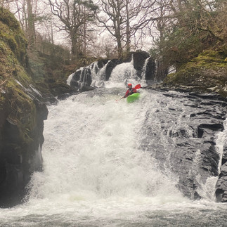
A fun continuous grade 2-3 intermediate sectionThe manky top rapid and triple waterfall series of Pont Cyffwg (6) is an interesting puzzle for paddlers hungry for freefall and technical challenge to figure out, especially considering the last drop is considered a portage by most. For the majority of paddlers in most water levels however, this will be a portage along the road on river right where you will reach a footpath taking you back down to the water below. From here, the river begins a fun continuous series of rapids at a grade 2+, filled with boulder gardens, waves and interesting corners. The final flourish of this section is Forestry Falls. This is a lovely grade 3 rapid starting in the right channel after an island, dropping away toward a friendly ledge hole.
Swallow Falls: Ugly House to Forestry Track (53°06'04.3"N 3°50'11.9"W)
2 Kilometers Grade 4- or 5 depending on water level.
Where the two sports of Kayaking and Canyoning meet
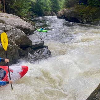
Swallow Falls is a sequence of 3 big drop offs, totalling 42 metres of elevation loss. Heading down through the gorge of Swallow with a mix of paddling and portaging is a good adventure in the right conditions (almost dry but not totally dry). The first thing to do is paddle to the top of the falls. There is a large island in the middle of the river on the high horizon line where you can land and inspect. From here, pick your way down a sequence of slides. Careful rope assisted movement may be required to navigate the more dangerous sections on slides 1 and 3. In a gorge like this, even portaging is part of the adventure.
Forestry Track to Betws Y Coed:
2.5 Kilometers Grade 4(6)
The best of the Llugwy: A true North Wales Classic
Follow the forestry path down from the A5 to an old abandoned stone building next to the river and put on. Over the next kilometre the river offers continuous whitewater boulder gardens starting at grade 2, turning into grade 3 and then finishing with a bang at Bench Falls (4). Bench is a long rapid where the whitewater steepens and then drops over a river wide ledge, which can make a decent hole in some flows. After Bench Falls, get out above the next rapid on the right and begin to walk the forestry path around Mincer.
When you reach the steps down to the Miner’s Bridge and see Miner’s Bridge Rapid (4) beneath, the portage has finished. The more adventurous paddlers may also want to walk back up a short way to view and consider running the last drop of the Mincer, which is named Shrinkwrapper (4+). These rapids in sequence represent some of the best advanced kayaking in the area, with an awesome mix of narrow, powerful slides and drops… All in a stunning ancient woodland setting.
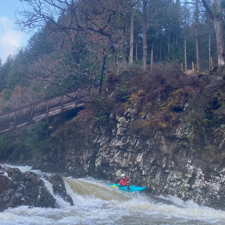
After leaving the Miner’s Bridge behind, the river will gradually calm again, from grade 4 back to 3, and eventually to 2. Dog walkers, picnic benches and houses in view will mark your approach to Betws Y Coed. Take out on the river left at Pont Y Pair Falls (4+). This drop is affectionately known by the paddling community as Chip Shop Drop, since it is right next to a great place to grab lunch. Pont Y Pair/‘Chip Shop’ needs a decent medium water level or higher to allow a kayaker to paddle right up and over the river's central boulder, before landing and powering through the chunky stopper under the bridge. To take out after the falls, walk back up through the far left arch over the rocks and back to the car park.
There is another upper section of the Llugwy on the moors above Capel Curig. It isn’t paddled often but could be worth an adventure. https://www.ukriversguidebook.co.uk/rivers/wales/north/afon-llugwy-upper-section-to-capel-curig


Comments